
You may remember that through the worst of the pandemic I was taking frequent walks through different portions of the Cleveland Metroparks System. Here in the Greater Cleveland area we are extremely fortunate to have our Metroparks. It is one of the finest park systems in the country... in fact in 2021 it was once again named the best park in the nation.

Even though it is December, the weather has allowed me to take a couple of long walks in the park this week. On Wednesday I parked my car along the Valley Parkway and took a six mile round trip walk along one of the park's pedestrian / bicycle paths. This particular path stretches over twelve miles from Berea following the course of the Rocky River northward almost to the shore of Lake Erie. I walked from the 12.5 mile marker near the Berea Falls to the 9.5 marker at the Big Cedar Point Picnic Area (which is not to be confused with the famous Cedar Point Amusement Park in Sandusky, Ohio) and back.
Yesterday was a chilly but sunny day, so I took another walk. This time I parked the car at Big Cedar Point to continue farther along the Valley Parkway's path.

Shale cliffs rise above the Rocky River at Big Cedar Point. Notice the stairs which climb up the escarpment which is known as Fort Hill. At the top there are the remains of 2000 year old Native American earthworks. I have climbed up the stairs a couple of times, although I have not found the earthworks. I was tempted to go up the 155 steps again, but I decided that I wanted to do another six-mile walk. Since I started at milepost 9.5, that meant that I would need to continue to milepost 6.5.

The Rocky River just beyond Big Cedar Point

The paved path accommodates walkers and cyclists.
I came to the impressive span of the Brookpark Road Bridge which was built in 1933.

I was a bit shaken when I saw a sign under the bridge warning of falling concrete. Yes, we really need an infrastructure bill!
Just after milepost 7, I came to the area of the parkway where there are signs with pictures of the planets. They are positioned at a distance from each other that is proportionate to their distance from the sun in the Solar System. They obviously revised the signs since scientists decided that Pluto did not deserve the status of a planet. The first one that I came to was Neptune.

As I continued along my final half mile, I passed Uranus and Saturn.


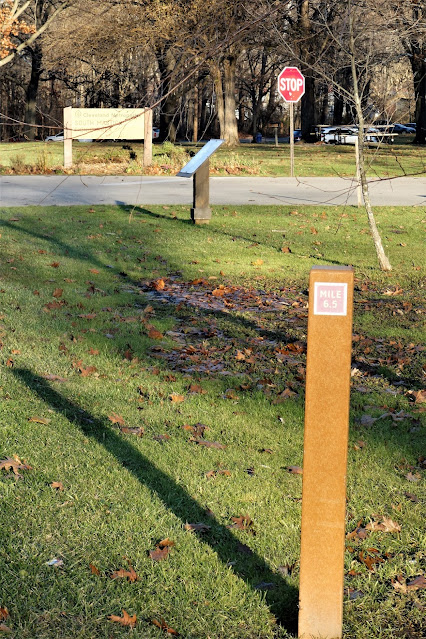
I finally reached my goal... the 6.5 milepost... near the entrance to the South Mastick Picnic Area.
Just beyond the marker was Jupiter.

I was not going to continue my journey through the Solar System, however.
It was four o'clock, and I wanted to make the three-mile return hike and get back to my car before sunset.

The December sun had sunk below the tree line by the time I made it back to Big Cedar Point.
My area also has a bike path that places the sun and planets in their proportional distances from each other. They use a different scale because it's 23 miles from the sun to Pluto (I don't know if they've removed that marker or just updated the sign because it's been several years since I've ridden the entire route). So maybe it's a good thing you didn't try to walk the entire solar system in one day! Haha!
ReplyDeleteOur solar system in the Metroparks is much condensed. I went from Neptune to Jupiter in less than half a mile. I'm sure that if I had gone another half mile I would have made it to the sun. But then it would have been dark before I got back to my car.
Delete